GOES-R, Fire Temperature RGB Quick Guide


Geostationary Operational Environmental Satellites — R Series
A Collaborative NOAA & NASA program & NASA SPoRT
Mission
NOAA’s most sophisticated Geostationary Operational Environmental Satellites (GOES), known as the GOES-R Series, provides advanced imagery and atmospheric measurements of Earth’s weather, oceans and environment, real-time mapping of lightning activity, and improved monitoring of solar activity and space weather.
Monitoring weather on Earth and in space
The GOES-R Series imager scans Earth five times faster with four times the resolution and three times the number of channels than previous GOES for more accurate and reliable forecasts and severe weather warnings. GOES-R Series satellites can provide images of weather patterns, hurricanes and severe storms as frequently as every 30 seconds.
The GOES-R Series provides critical atmospheric, hydrologic, oceanic, climatic, solar and space data, significantly improving detection and observation of environmental phenomena that directly affect public safety, protection of property, and our nation’s economic health and prosperity.
Benefits
√ Improved hurricane track and intensity forecasts
√ Increased thunderstorm and tornado warning lead time
√ Earlier warning of lightning ground strike hazards
√ Better detection of heavy rainfall and flash flood risks
√ Better monitoring of smoke and dust
√ Improved air quality warnings and alerts
√ Better fire detection and intensity estimation
√ Improved detection of low cloud/fog
√ Improved transportation safety and aviation route planning
√ Improved warning for communications & navigation disruptions & power blackouts
√ More accurate monitoring of energetic particles responsible for radiation hazards
Why is the Fire Temperature RGB imagery Important?
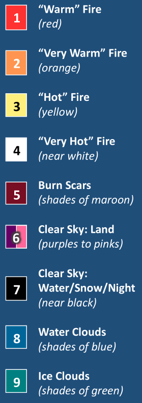
This RGB allows the user to identify where the most intense fires are occurring and differentiate these from “cooler” fires. The RGB takes advantage of the fact that from 3.9 µm to shorter wavelengths, background solar radiation and surface reflectance increases. This means that fires need to be more intense in order to be detected by the 2.2 and 1.6 µm bands, as more intense fires emit more radiation at these wavelengths. Therefore, small/cool fires will only show up at 3.9 µm and appear red while increases in fire intensity cause greater contributions of the other channels resulting in white very intense fires.

Fire Temperature RGB Recipe

Impact on Operations
Primary Application

Fire hotspot locations are detected: The saturation brightness temperature of the short wave-IR 3.9 µm channel is low, around 500 K (i.e. relatively low intensity fire). Therefore, “hotspots” of wildfires look red in RGB.
Fire intensity can be analysed: High intensity fires are near a maximum of 1400 K and this is near the peak emission detection (i.e. saturation) of the 1.6 µm channel. Therefore, active fires in the RGB transition from red to yellow to white as intensity increases and near-IR channels become saturated.
Limitations

Cloud cover blocks view of fire: The fires will only be visible in the RGB in clear sky areas.
Cloud features/type have fewer details: While water vs. ice clouds can be identified, other RGB products are better at displaying cloud features.
Daytime only application for clouds: The reflectance from clouds are not available at night in the near-IR bands used in the RGB.
False “red” fires due to land type: Some surfaces in arid, dry regions are highly emissive at 3.9 µm and will appear red, but they are not on fire.
RGB Interpretation

Fire Temperature RGB from GOES-16 AIB at 1807 UTC, 24 June 2017 (above). Inset #1 provides a zoomed-in view of active fire at 1952 UTC over southwest Utah for both day (left) and night (center); Inset #2 is a zoomed-in view over northern Nevada for 25 July 2017 showing a burn scar.
seasonally, and latitudinally.
RGB Colour Guide

Comparison to Other Products
The True Colour RGB shows smoke from the fires, but does not distinguish the intensity like the Fire Temp. RGB. While missing the smoke, the Fire Temp. RGB provides insight to active fire location and behaviour.

Resources:
UCAR/COMET — Multispectral Satellite Applications: RGB Products.
VISIT Program Satellite Chat: Ft. McMurray.
Fires CIRA Blog “Fire” related posts.